Poison Spider Mesa
 Poison Spider Mesa forms one of the cliff features that is part of the Moab landscape northwest of town. The mesa is bordered on the east by Moab Valley and on the south by the Colorado River. Access is via Scenic Byway 279, the "Potash Road," and the trail climbs to the rim along with the sloping rock layers. The first few miles of trail must be retraced, but most of the travel time will be spent on a loop that reaches the rim. It has deservedly become one of our most popular trails because it has great scenery and because the jeeping is just challenging enough to be fun without quite being a vehicle buster. Incidentally, we love the name, but the population of Black Widows is probably no greater than other local areas.
Scenery
The vista across the fins of Behind the Rocks toward the La Sal Mountains is as fine as they come. The rim view overlooks Moab 1,000 feet below and includes a panorama of about 300 degrees . The usual lunch stop is just above so-called "Little Arch." Jeep Arch (about 3 miles away) is seen clearly from near the rim.
Surface
Much of the loop portion is on Navajo Sandstone slickrock, with one stretch of 0.4 miles of bare rock. There are also rock ledges, sandy washbottom, and two blow-sand hills.
Trail Details
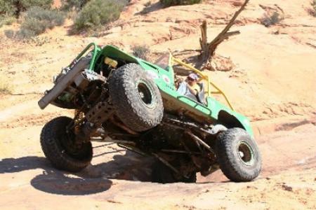
This trail departs Utah 279 at a well marked turnoff and a sizeable parking area. Route finding can be very difficult after the first five miles, as the trail gets onto slickrock and follows it extensively from then on as it completes a large loop. The trail was marked some time ago with jeep shaped markings, and as these have worn off the have been replaced with simple white lines or white dots, but depending upon how recent the painted markings have been renewed their visibility might be limited.First up on the trip is a series of switchbacks that are getting rougher, if they prove difficult be advised the trip only gets rougher so turning back should be considered. Once up the switchbacks the next obstacle is a rough descent over a notch section that demands proper tire placement to keep out of trouble, although this spot features a bypass to the left.
About two miles in the trip encounters a short section of shelves as it heads into a small canyon and then travels a sandy washbottom. The sand ends at the first major obstacle, called The Waterfall. One starts up to the right on an off camber hill then heads to the left to travel across the face, angling downward on the driver's side. Once across this, it climbs steeply and then turns right.
Now the route heads up a loose rubbly hill and then goes right up a large slab of rock that angles steeply up from its sandy approach. Sometimes several attempts are required to surmount this obstacle. Once up this spot the road does a 180 turn to continue the climb. First it is just loose rock, but then at the next corner another large rock slab signals the next challenging climb, which may also require several attempts. Once up this the trip eases up a bit and briefly heads through a section that offers great scenery with views of the Behind the Rocks area and the La Sal Mountains.
This section ends at the approach to the next challenge, called the V Notch. Careful tire placement allows a vehicle to straddle the notch and complete the climb, but a bypass is available to the left. Less than a half mile from here a sandy section ends at a slickrock wall that feature several different ways to climb it, each of varying difficulty.
Once up onto the flat slickrock the trip starts across a long series of bumpy ledges and holes that will make your head feel like it is attached to your body with a slinky. Endure this section and the trail starts getting smoother, finally hitting a long smooth section atop the mesa. About five miles into the trip the smooth roadbed ends as the roadbed moves onto the white Navajo sandstone with all its varying humps and lumps.This is when route finding can be difficult depending upon the age of the markings. The trail does somewhat of a backwards S through this section and after about .1 mile the intersection that features the start of the Golden Spike Trail is encountered. Golden Spike features yellow colored spikes as its markings, as well as warning signs; Poison Spider is indicated with an arrow pointing a right turn heading downhill here.
From the Golden Spike Trail it is about 1/4 mile to the beginning of the Poison Spider loop. It starts in a little sandy spot that should have a carsonite sign pointing out a choice of either straight ahead or a left turn. The Safari starts by going straight to run the loop in a counterclockwise direction.
The loop starts a meandering, undulating roller coaster type trip over the slickrock and one has to be sharp to keep finding the marks that indicate the trail. After about six tenths of a mile from the start of the loop a broad, slightly sloping section of slickrock is found, and on the right had side the word Arch should be found painted on the rock with an arrow pointing the way. It is time to dismount and hike about 50 yards to view the arch below. By getting the proper alignment the Rim Trail can be seen across the Colorado River far below. This spot is usually a good place for a lunch break as well.
The loop continues from the arch view by climbing steeply straight up and it then begins wandering along the various Navajo fins, bumps, and lumps. It twists around the edge of a large pothole; the challenge is to keep locating the next white mark to stay on the route, an occasional rock cairn may also help. The loop is about 3.4 miles long if no detours or wrong turns are made, and when one arrives back at the carsonite sign all that remains is to retrace the trip over all the obstacles encountered on the way in.
Trail Rating

Trail Notes
Length: 31 total, 16 off highwayMin Tire Size: 33+ inches
Winch: No
Front Locker: No
Rear Locker: Yes
Trail Gallery


 DOWNLOAD THE KML GOOGLE EARTH TRACK