Copper Ridge
 This trail is a combination of several roads north of Moab and near the western boundary of Arches National Park. It lies east of the Moab Fault, so is in younger rock formations than many of our trails. Its slickrock is the top of the Entrada Formation, and its views are often of erosions into that formation. Prominent scenic exposures are in an area called Klondike Bluffs; you may have seen a preview on your way here from Highway 191. Some of the roads are on the softer Morrison Formation, which can be impassably slippery when wet. In case it is completely dry, most of the trail could have a lower rating, but there are eroded trail portions that can challenge stock vehicles.
Scenery
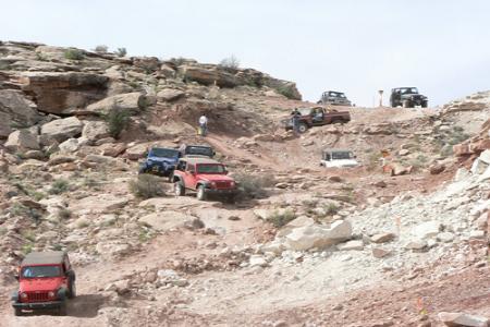
The trail goes to an unexpected and beautiful pour-off into lower Sevenmile Canyon and follows near that canyon rim to the junction with Courthouse Wash where it has cut into the Entrada Formation. The Klondike Bluffs exposure of white-capped red rock towers and canyon walls are at a moderate distance. There is a good view of Tower Arch, and some other arches are seen at a distance. Highlights - the trail goes near colorful hills that have yielded dinosaur bones. Toward the end of the day some nicely exposed dinosaur tracks may be visited on foot. Followong the main section of slickrock are 2 steep climbs on eroded dirt and rock. It also passes a few fading remnants of a movie set used in the 1960's film "Blue" with Ricardo Montalban
Surface
Most of the trail is dirt and rocky dirt, but there are a couple of long stretches of slickrock, and some broad, sandy washbottom.
Trail Details
The Copper Ridge Trail combines several different roads to explore an area north of Moab, east of US191, and just west of Arches National Park. Due to the numerous combinations of the area's roads that various Red Rock 4 Wheelers trail leaders have tailored their trips to include or exclude some sections of the actual permitted trip. The National Park Service also decided a number of years ago to discourage the Club's use of one segment. Therefore, this description will cover the entire route, but also mention other possible travel choices as they are encountered. TWO IMPORTANT THINGS TO NOTE: this trail is comprised of large sections of the grey soils of the Mancos Shale and Morrison Formation; these soils are nearly impassible when wet, travel is not advised for several days after significant rain or with melting snow. The second item is this trail description includes sections that are not shown on the BLM trace shown belowThe access point to start the trip is a right turn off US191 north of Moab at a sign that points out the Bar M Chuckwagon restaurant. Once off the highway the main trip heads to the right, back toward Moab. To eliminate the first section of the trail, one can go left to shortcut to the pouroff of lower Sevenmile Canyon. Assuming the entire trail is selected, the parking lot for the Bar M is passed and soon the paved bike path emerges from under US191 and parallels the dirt road for motorized vehicles. Despite what it looks like, traveling on the dirt road to the left of the bike path is legal, it is a county road. This road eventually ends, but a trail to the left should be marked with a carsonite sign that says "Bar M Loop". This starts the first section of the Copper Ridge Trail. The route soon encounters a short hill; as it climbs up this hill a rough, eroded section may require some careful tire placement to get through. Once up the hill the route head southeast for a little bit to encounter a large expanse of slickrock. A left turn as the slickrock is reached heads one generally north; occasional carsonite signs will appear indicating the Bar M Loop's path. It is helpful in this part of the trip to watch for paint marks on the slickrock, and to remember the correct route generally hugs the left (western) side of the slickrock, staying close to the edge where the dirt hills and slickrock meet. This section is pretty easy as far as jeeping goes, but very scenic. Keeping an eye out to the right (east) allows careful observers to spot arches and various rock formations of the Windows Section of Arches National Park.
Eventually this part of the trip starts to drop down to pass near a gas pipeline right of way, then goes through a gate in a fence line. It then turns right out onto slickrock, and left to cross a sandy and rocky wash. This is Sevenmile Wash, and heading a little right gets one to the edge of the pouroff into lower Sevenmile Canyon. This stop is well worth making, it is a beautiful canyon. Once ready to resume travel, another choice must be made. The Easter Jeep Safari leaves the slickrock on a road visible to the north, climbing a hill. An option open to groups under 25 (i.e.those that don't require a permit) is to head east along the canyon. This choice has one pass through a green gate (entering the National Park) and continuing along on the slickrock. The travel is much the same as the Bar M Loop section, staying on the left edge of the slickrock, just to the right of the dirt hills to the left. As the trip turns to head north on the slickrock a canyon becomes visible to the right. This is Courthouse Wash on its way to join up with Sevenmile Wash. Eventually another green gate is encountered, and the trail leaves the Park to drop into the sandy bottom of Courthouse Wash (much shallower here). It then continues in the wash north until it encounters Willow Springs Road, where the main Copper Ridge Trail is rejoined with a right turn.
Assuming that the choice is made at the pouroff of Sevenmile to stay with the EJS route, the hill to the north is ascended, and the trip heads generally north until a fenced gas line facility is encountered. The left road is used to head directly toward the Archview Campground. Just before reaching the campground's fence a road heading north on a pipeline right of way appears; a right turn onto this road starts the trail heading north again. This section, while a little confusing at first, soon becomes one clearly defined road along the right of way. A slight rise is passed and a small valley opens to the right, a carsonite sign even points out the way to head into this valley as an ATV and Jeep route in the Sovereign Lands Trail System. Leaving the pipeline behind, the trail twists back and forth in this valley to find a way to its mouth. It eventually ends up in the wash bottom and it follows it until a steep drop in the wash forces the route to climb a little hill to get out of it. Some large boulders are twisted by, and a good trail heads north. Very quickly now a county road is encountered; this is Willow Springs Road. A right turn onto Willow Springs Road heads one east, across sandy Courthouse Wash and then to another intersection. Willow Springs Road continues east but the Copper Ridge Trail turns left to go north. There are carsonite signs along the way, but they are usually marked with a "Sovereign Trail" marking. This left turn features a brown sign announcing that one is entering Sovereign Lands. The Sovereign Trail system was developed by a local motorcycle club from old mining roads in this area. It includes trails for single track (motorcycles and bicycles) and full sized roads (4x4, ATV, UTV). A lot of the carsonite signs mention only the Sovereign System, but a few also feature a Copper Ridge sticker as well. This part of the Copper Ridge Trail is obviously on a full size route as it heads north. It twists around a few old mine holes in the first section, and then it tours some interesting scenery as it passes through an area Jack Bickers named "Rock City"; you may have seen one of his guidebooks detailing roads and hikes in this area. A bit over two miles of travel and another main county road is encountered, the Dalton Wells Road. A right turn to head east on this road continues the trip.
The road is now heading north east along another wash bottom. Large dark brown blocks of rock litter the ground to the left; this is the Dakota Sandstone rock layer eroding and tumbling down the hillside. Depending upon rains and use the road bed moves around a bit through here, a couple years ago in one place a three foot channel was eroded from the right track in one rainstorm. As it approaches a large slickrock slope the road forks twice in a short distance. The first intersection features a straight fork that climbs to ascend a hill via a long shelf road (dugway in local terms). It is a single track only now due to rock slides, so going left is the proper choice. The next fork is at the bottom of a hill as the road drops into the wash and left is the proper way here. The route twists around a bit in the wash to emerge heading northeast onto the large slickrock layer. It can be seen ahead climbing a rubbly reddish dirt hill and a carsonite sigh points the way. This large slickrock area here is the reason the road washes out, as the slickrock serves as a funnel to channel water into the wash. Once through the rubbly section the trail climbs onto a narrow red dirt ridge that separates the huge slickrock expanse on both sides. At the end of the ridge the route has a sign directing one to the left onto the slickrock. A larger sign explains the proximity to the national park boundary and the need to stay on the proper route. White paint marks point out the correct way to cross the slickrock. At first the route doubles back paralleling the ridge back down the slickrock, heading slightly right. As the trip nears the bottom end of the slickrock it turns right and then starts heading northeast, rounding a point it next turns north. Occasional carsonite signs also help point the way. Soon signs hammered into the rock announce the National Park boundary, and point the way to the left to continue. A small tree blocks the view at first, but then the road appears climbing a little hill rather steeply to get off the slickrock. At this point the trail is heading straight west as it heads through a red soil valley for a little way. Soon the soil color turns to gray. The road then turns right to ascend a tough little hill that may cause some trouble depending upon recent rains and continuing wear.. The first part of the hill begins with a squeeze between some large rocks, and then the climb begins, usually with loose rocks littering the left side from water drainage, and maybe some rutting also. At the top of this section the trail heads left; a fair sized rock must be overcome as it sits squarely in the middle of the road. After this the rate of ascent backs off and the rest of the way to the top is easier. After snaking through a section of trees another grey soiled flat is encountered. Numerous little ruts cross the road from rain water flowing across it. Soon the road turns right and encounters another graded county road. For those with decent maps, this is the Little Valley Road.
The Copper Ridge Trail turns right onto this road. High above on the left is a mesa with colorful slopes of green, red, and some grey, all part of the Morrison Formation. There was a dig for dinosaur bones on the top many years ago. In some places the grey soil has washed onto the county road, looking very much like flows of concrete. The trail uses the county road for a little less than two miles. It departs to the right, just as one is slowing for a little dip; a carsonite sign points the way. It now heads on the grey soil roughly northeast through a gap between two hills. Overall this section is roughly .6 mile, and more Park Service signs appear on the right side as the road begins to turn left, it then drops onto slickrock. It generally hugs the left side along the hill, twisting around trees and holes and cracks in the rock. After roughly .3 mile on the slickrock the road appears straight ahead through the trees as it climbs a slight incline, but this isn't the way. Instead, the Copper Ridge Trail heads left in a small drainage, and sharp eyes soon pick up the route doubling back southeast to start climbing the hill above. The climb soon heads southwest and west as it climbs steeply up the hill. Once on top it twists around to gain the final bit of elevation to the top and eventually heads northwest.
This is the place to stop and get out of the vehicle. Looking north to north east one should spot Tower Arch not too far away. The formation the arch is in is called the Marching Men in the Park's information. Now the trip heads west to descend the hill, heading back to the Little Valley Road. The descent is rather bumpy as numerous shelves are descended to get back to the valley floor. Back at the Little Valley intersection again a look to the left may spot the ruins of a little white church left over from filming of the 1968 movie "Blue" that starred Ricardo Montalban. The Copper Ridge trip continues by heading right onto the Little Valley Road.
Now the trip offers another choice. Heading northward on the county road (Little Valley) roughly .8 mile, at a wide grey colored flat, an intersection is encountered. Initially a road heads off to the right as another is seen coming down a mild hill to the left. If one ignores the first right, the road coming downhill to the left is quickly encountered. This road is the Klondike Bluffs Road shown on a decent map. The choice is to end the trip via a left turn onto Klondike Bluffs Road, and a return to US191 just shy of the Moab airport; then a left turn onto US191 for the trip back to Moab. The other choice is a right turn to continue up Little Valley. The Copper Ridge Trail makes this second choice. If this choice is taken, the trip involves about a five plus mile dusty trip north, crossing numerous dips and small gulches. At the northern end, another road is spotted coming downhill from the left. At the intersection with this graded road, a right turn heads one onto the final leg to the dinosaur track section and the difficult climb to the old copper mine. The left fork heads to US191, and once there a left turn heads one back to Moab.
Taking the right fork at this point to run the entire Copper Ridge Trail, it doesn't take long to arrive at a BLM parking lot, interpretive sign, and a pit toilet. Another choice now arises. One can choose to park here and hike up the well marked path to view the dinosaur tracks. Another choice, not very apparent but totally legal, is to drive uphill, just to the right of the hiking path, and climb the hill. This trip is quite a bit more difficult than the trail has been so far, upping the difficulty rating into the 4-5 range. Once up the first hill, the route starts up a nasty, water rutted, rock filled section that demands careful tire placement to successfully complete. It then bears left, heads through an old gate, and starts into a huge bowl shaped area that is the lower section of an old copper mine. Numerous side routes exist, but the idea is to continue heading steadily uphill by the most obvious route. While it seems longer, this last section from the BLM parking lot to the top is only about a mile in length. An old BLM sign reminds travelers of the dangers of old mines. One passes by numerous signs of the mining activity, old rotting rubber hoses, settling ponds, plastic pipes and the remains of concrete settling boxes. The final climb becomes obvious at the head of the valley; it features a switchback ascent along a shelf road that gets stressfully narrow at a couple places. As the road rounds the corner from this section the roughest section of the trip is encountered. The road is water washed with healty holes and large rocks to be overcome. It then turns left from this section and completes the ascent to end in a loop at the remains of the diggings of a mine. A large metal storage tank and some pipes and other debris are also scattered around. The view into the Salt Valley section of Arches National Park to the east, and to US191 to the west is pretty interesting as well. The trip back retraces the ascent route to the BLM parking lot, then back to the intersection at which a right turn was chosen. Here, heading right will head one over a small hill, and then start one on a northward path. US191 traffic is visible to the left, and eventually the road turns left and ends at that highway. A left turn gets one heading back to Moab.
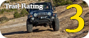
Trail Rating
Trail Notes
Length: 64 total, 35 off-highwayMin Tire Size: stock
Winch: No
Front Locker: No
Rear Locker: No
Trail Gallery


 DOWNLOAD THE KML GOOGLE EARTH TRACK